I hope everyone is safe from Hurricane Sandy! This is one of the worst storms to ever hit the East Coast. Millions are without power, houses are destroyed, and there are over a billion dollars worth of damages. I wish all those affected the best of luck in restoring power and rebuilding whatever may have been destroyed.
-Zohar Zamir
Assessing the Damage From Hurricane Sandy
Power Failures


MASS.
MD.
OHIO
W.VA.
CONN.
R.I.
N.J.
DEL.
VA.
PA.
N.Y.
N.H.
VT.
ME.
100,000
10,000
Spread of Power Failures
Across the Northeast
Customers without power

Pa.
Conn.
New Jersey
New York
1:30 a.m.
7:30 p.m.
1:30 p.m.
7:30 a.m.
Monday
2 million
4 million
6 million
13 states
Based on updates from 35 major power companies
Customers Without Power
Ambulances lined up to take patients to other hospitals, after the backup power system failed at NYU Langone Medical Center.


 Areas of lowest elevation
The skyline of Lower Manhattan in darkness. A fiery explosion at a substation on 14th Street left about 250,000 customers without power.

 Areas of lowest elevation
Avenue of the Americas was dark after the power failure that affected most of Manhattan south of 34th Street.

 Areas of lowest elevation
Flooding
The water came up to my knees when I joined my neighbors on the front stoop. @ Avenue C and 14th Street instagr.am/p/RYnABRRiEo/


 Instagram
  Areas of lowest elevation

 Areas of lowest elevation
Flood waters reached the corner of Canal and Hudson Streets. Most of Manhattan south of 34th Street lost power after a substation exploded.

 Areas of lowest elevation
Sea water flooded the Ground Zero construction site.

 Areas of lowest elevation
A car in Brooklyn took refuge on the sidewalk outside of McDonald’s under the B.Q.E. in Carroll Gardens.

 Areas of lowest elevation
Streets were flooded under the Manhattan Bridge in Dumbo.

 Areas of lowest elevation
Red Hook, Brooklyn, was flooded twice on Monday. Members of the New York National Guard patrolled the area.

 Areas of lowest elevation
Wind
Fires
In Breezy Point, on the Rockaways, a fire destroyed about 80 homes.

 Areas of lowest elevation
Subways and Railroads

12 ft.
9
6
3
Areas that could be
flooded if the water
reaches a height
above normal of:
The lowest subway entrance
is at the 6- or 7-foot surge
level. Studies have suggested
that if the surge reaches 8 to 10
feet, a number of East River
tunnels would be fully flooded.
Subway Lines
Vulnerable To
Flooding
Subway
tunnels that
could be
flooded in a
100-year flood,
roughly equivalent
to a surge of 8 to
10 feet.
3
1
2
A
A
D
N
F
Q
B
C
C
5
4
5
4
3
2
R
BROOKLYN
Hudson
River
East River
Battery
Park
City
Battery Park
MANHATTAN
Vulnerable
subway entrances
and vents
Workers pumping water out from the tracks at South Ferry subway station on Tuesday.

 Areas of lowest elevation
Staten Island Railway's Clifton shop was flooded with debris.

 Areas of lowest elevation
The tracks at Metro North Railroad's Croton-Harmon station were inundated.

 Areas of lowest elevation
A boat resting on the train tracks at Metro-North's Ossining station.

 Areas of lowest elevation
Other Transportation
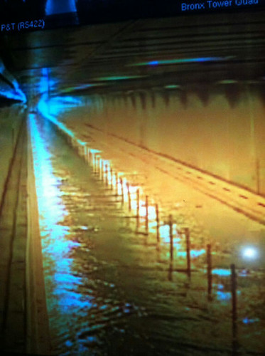
Traffic surveillance camera shows floodwaters in the Hugh L. Carey Tunnel (Brooklyn Battery Tunnel.) #Sandy flic.kr/p/dp2B8z


 Areas of lowest elevation
Water rushed into the Carey Tunnel (previously the Brooklyn Battery Tunnel) in the Financial District. Seven subway tunnels under the East River were also flooded.

 Areas of lowest elevation
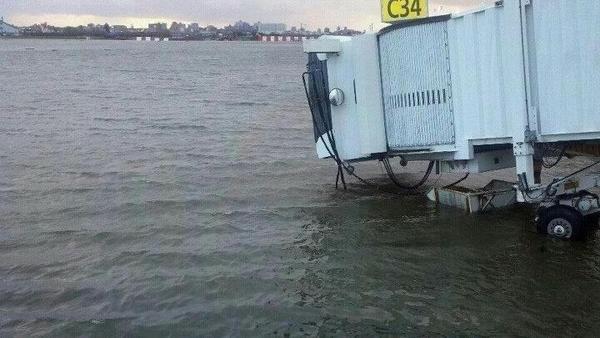
Floodwaters from Hurricane Sandy rushed into the PATH station in Hoboken, New Jersey, through an elevator shaft.

 Areas of lowest elevation
A view of the Battery Park Underpass on Tuesday morning.

 Areas of lowest elevation
10/30 update: Recovering from Hurricane #Sandy bit.ly/W2JTT8 pic.twitter.com/VDoRgC5q


Comments(0)