An issue I was totally
unaware of, sadly so because I have been a lifelong resident of Western
States, is the issue of Checkerboard
Land Use. Dating back to the 19th century, the Federal
government granted railroad companies every other square mile of
land for 20 miles on either side of railroad routes
creating a checkerboard pattern of land ownership - particularly in
western states.
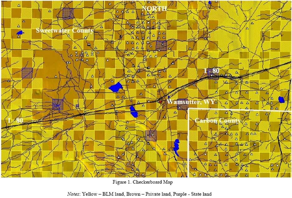
This
picture, borrowed
from a 2001 study by the Wyoming Oil & Gas Industry,
illustrates
the difficulty of working in the checkerboard environment - remember,
every other square mile for a 40 mile wide swath across the heartland
of the country. This can make it
difficult for the public to get to federal land, parks or recreation
facilities for example, without crossing private property, or for
private landowners to access their property without crossing federal
lands. It also makes development and management of these lands
different - public lands have different management standards than
private - and this challenge to use and development can have a real
devaluing effect on a parcel, the oppostite of the original intent of
the program. This effect may ripple out through an entire community and
can negatively impact local real estate markets, land use and tax
basis.
To give you some idea of the scope of this problem - Nevada is our 7th largest state encompassing some 70,745,600 acres. The federal government controls 60,863,345 acres, or 86.1%. 11.5% is privately owned, 1.6% is tribal, .04% is state owned and .04% is local. Of that 11.5% of privately owned land, 63% of that is in a Checkerboard land pattern. And while Nevada might be the largest impacted state, the federal government owns over 553,000 square miles, or 47% of the 11 states west of the Rockies, excluding Hawaii and Alaska. In Utah, where 64% of land is federally owned, the state government has been trying to work out some sort of equitable compromise since the mid-80's. In New Mexico, which has about 6.3 million acres of checkerboard land scattered across 5,000 tracts, it took over 40 years to negotiate the exchange of 340,000 state acres in the White Sands Missile Range. All they wanted to do was consolidate some parcels to blow up in exchange for other contiguous parcels that could have been developed or used for other purposes. 40 years.
To give you some idea of the scope of this problem - Nevada is our 7th largest state encompassing some 70,745,600 acres. The federal government controls 60,863,345 acres, or 86.1%. 11.5% is privately owned, 1.6% is tribal, .04% is state owned and .04% is local. Of that 11.5% of privately owned land, 63% of that is in a Checkerboard land pattern. And while Nevada might be the largest impacted state, the federal government owns over 553,000 square miles, or 47% of the 11 states west of the Rockies, excluding Hawaii and Alaska. In Utah, where 64% of land is federally owned, the state government has been trying to work out some sort of equitable compromise since the mid-80's. In New Mexico, which has about 6.3 million acres of checkerboard land scattered across 5,000 tracts, it took over 40 years to negotiate the exchange of 340,000 state acres in the White Sands Missile Range. All they wanted to do was consolidate some parcels to blow up in exchange for other contiguous parcels that could have been developed or used for other purposes. 40 years.
The negotiations get
even trickier when dealing with tribal lands which are
subject to multiple owners, conflicting jurisdictions and include the
coordination of services across these chasms. Further, the federal
government is supposed to make payments to states in lieu of taxes for
all these public lands. However, these payments are either not made at
all, not made in a timely manner, or don't accurately reflect the loss
of tax revenue. In one recent case in Elko, NV, one section was
developed into 13 X 40+ acre parcels. Previous taxes paid by the
federal government was $28/yr. on that section. Just by creating the
parcels, taxes on the section increased to $2,500/yr. Homes have been
built on three of the parcels bringing tax revenue to over $7,400/yr. Lets see, increase local
revenue and utility, decrease federal spending and oversight, improve
local land use, enhance protection of endangered species, expand
private property rights - naw, that'll never fly.
Congress already has the authority and direction from the Federal Land Management and Policy act of 1976 to consolidate the public lands. The problem, according the experts, is that the agencies that can accomplish this are underfunded thus rendering them unable to deal with more than the cursory day to day management of the vast tracts of federal and. In cases where private land owners have pursued consolidation, the government has forced them to pay all the associated costs, usually making it impractical to proceed. Both parties agree that consolidation of these parcels would result in improved access for both public and private use, local and state tax bases would improve as the land was developed to it's highest and best use, and management of eco systems would be uninterrupted contributing to a healthier wildlife environment.
Congress created this problem - albeit over 100 years ago, but we need their help to fix it today. Successful resolution of the Checkerboard land use issue is a public benefit as well as a benefit to private, state and local governments. NAR has been pursuing this as a legislative resolution for years - way to many years according some locals involved in the fray. They are encouraging expanded actions by NAR to encourage congress to make this a priority for the public land management agencies as well as provide their full cooperation in time and shared funding for any private land- owners willing to work with them.
You can find more information by searching the www.Realtor.org database or by visiting one of the following sites:
http://volokh.com/posts/1214914572.shtml
http://www.bqaz.gov/PDF/Northern_WP2_LandUse_3.pdf
http://www.consbio.org/what-we-do/science-assessment-for-the-sierra-checkerboard
http://www.bus.ucf.edu/wp/content/archives/Checker11-20-01.pdf
Gene
Wunderlich - Selling Southwest California Homes including
Temecula, Murrieta & The Southern California Wine Country


'NAR Update - Checkerboard
Land Use Patterns'
THE
OPINIONS IN THIS
COMMENTARY ARE STRICTLY GENE WUNDERLICH's PERSONAL OPINION. WHILE ANY
REASONABLE &/or RATIONAL PERSON SHOULD AGREE, THESE VIEWS MAY
NOT
REFLECT THOSE OF ACTIVERAIN, COLDWELL BANKER RESIDENTIAL BROKERAGE OR
ANY LOCAL, STATE OR NATIONAL ASSOCIATIONS.


Comments (3)Subscribe to CommentsComment